| Land
use |
 |
|
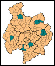 |
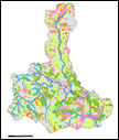
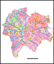
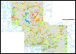
SAM
Program research sites in Bac Kan province. |
| |
|
|
| Ngoc
Phai commune, Con Don district |
|
|
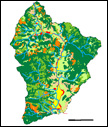 |
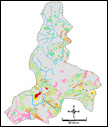
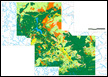
1983
land use map of Ngoc Phai commune, Cho Don district. |
|
|
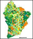 |
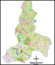
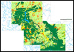
1989
land use map of Ngoc Phai commune, Cho Don district. |
|
|
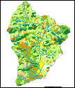 |
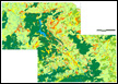
1995
land use map of Ngoc Phai commune, Cho Don district. |
|
|
 |
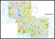
1998
land use map of Ngoc Phai commune, Cho Don district. |
|
|
 |
1983
- 1989 land use change map of Ngoc Phai commune, Cho Don district. |
| |
|
|
| Nghien
Loan commune, Ba Be district |
|
|
 |
1952
land use map of Nghien Loan commune, Ba Be district. |
|
|
 |
1998
land use map of Nghien Loan commune, Ba Be district. |
| |
|
|
| Thanh
Mai commune, Cho Moi district |
|
|
 |
1952
land use map of Thanh Mai commune, Cho Moi district. |
|
|
 |
1977
land use map of Thanh Mai commune, Cho Moi district. |
|
|
 |
1998
land use map of Thanh Mai commune, Cho Moi district. |
|
|
 |
1952
- 1977 land use change map of Thanh Mai commune, Cho Moi district.
|
|
|
 |
1977
- 1998 land use change map of Thanh Mai commune, Cho Moi district. |
| |
|
|
| Van
Tung commune, Ngan Son district |
|
|
 |
1952
land use map of Van Tung commune, Ngan Son district. |
|
|
 |
1998
land use map of Van Tung commune, Ngan Son district. |
|
|
 |
1952
- 1998 land use change map of Van Tung commune, Ngan Son district. |
| |
|
|
| Xuat
Hoa commune, Thi xa Bac Kan |
|
|
 |
1954
land use map of Xuat Hoa commune, Thi xa Bac Kan. |
|
|
 |
1977
land use map of Xuat Hoa commune, Thi xa Bac Kan. |
|
|
 |
1998
land use map of Xuat Hoa commune, Thi xa Bac Kan. |
|
|
 |
1954
- 1977 land use change map of Xuat Hoa commune, Thi xa Bac Kan. |
|
|
 |
1977
- 1998 land use change maps of Xuat Hoa commune, Thi xa Bac Kan. |
| |
|
|
| Lang
San commune, Na Ri district |
|
|
 |
1954
land use map of Lang San commune, Na Ri district. |
|
|
 |
1977
land use map of Lang San commune, Na Ri district. |
|
|
 |
1998
land use map of Lang San commune, Na Ri district. |
|
|
 |
1954-1977
land use change map of Lang San commune, Na Ri district. |
|
|
 |
1977-1998
land use change map of Lang San commune, Na Ri district. |
| |
|
|
| Luong
Thuong commune, Na Ri district |
|
|
 |
1954
land use map of Luong Thuong commune, Na Ri district. |
|
|
 |
1977
land use map of Luong Thuong commune, Na Ri district. |
|
|
 |
1998
land use map of Luong Thuong commune, Na Ri district. |
|
|
 |
1954-1977
land use change map of Luong Thuong commune, Na Ri district. |
|
|
 |
1977-1998
land use change maps of Luong Thuong commune, Na Ri district. |
| |
|
|
| Duc
Van commune, Ngan Son district |
|
|
 |
1998
land use map of Duc Van commune, Ngan Son district. |
|
|
| Ba
Be National Park |
|
|
 |
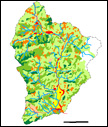
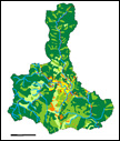
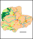
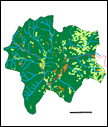
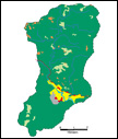
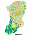
Land
use map of the Ba Be National Park area in 1983 |
|
|
 |
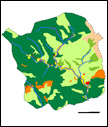
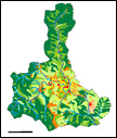
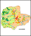
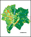
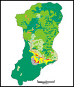
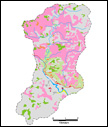
Land
use map of the Ba Be National Park area in 1989 |
|
|
 |
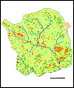
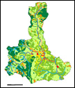
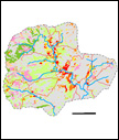
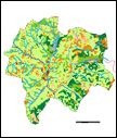
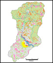
Land
use map of the Ba Be National Park area in 1998 |
|
|
 |
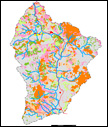
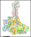
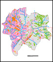
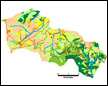
Land
use change maps of the Ba Be National Park area 1983 - 1989. |
|
|
 |
Land
use change maps of the Ba Be National Park area 1989 - 1998. |
| |
|