Research Sites
Bac Kan province was chosen in collaboration with our institutional partners for the following reasons:
- The geographic
importance of shifting cultivation systems in this province, and the
related risk of environmental degradation in fragile upland ecosystems,
is a main concern of national and provincial level decision makers,
- Bac Kan is
classified as the poorest province in Vietnam. It is thus challenging
to tackle agricultural development and rural livelihood issues in such
conditions in order to achieve a measurable impact on poverty alleviation,
- Moreover, the selection of this province was guided by the existence of many R&D projects that would benefit from a better integration of their activities.
Administrative map of Bac Kan province with SAM Program research sites
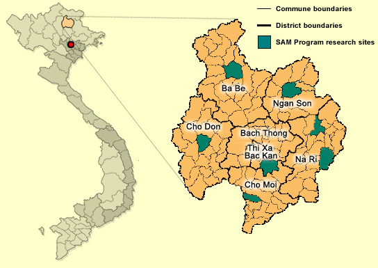
In 1997, we selected a research site in Ngoc Phai commune, Cho Don district, to develop tools and methods adapted to the main issues of agricultural intensification found in the mountainous province of Bac Kan. We introduced and tested innovative cropping systems there as alternatives to slash and burn cropping systems, from field to watershed levels.
As our program aims at generalizing locally obtained results to the whole province, we selected six other sites, distributed along a gradient of integration to market, and covering the entire range of agro-ecological diversity that can be found in Bac Kan. The pilot site selection procedure was supported by a specific GIS-based study on these two variations (i.e. integration to market and agro-ecological diversity). Participatory agro-ecological and socioeconomic zoning made sure that each selected site was representative of the district to which it belongs.